Sigiriya (Lion's rock) is an ancient rock fortress and palace ruin situated in the central Matale District of Sri Lanka, surrounded by the remains of an extensive network of gardens, reservoirs, and other structures. A popular tourist destination, Sigiriya is also renowned for its ancient paintings (frescos), which are reminiscent of the Ajanta Caves of India. The Sigiriya was built during the reign of King Kassapa I (AD 477 – 495), and it is one of the seven World Heritage Sites of Sri Lanka.
Sigiriya may have been inhabited through prehistoric times. It was used as a rock-shelter mountain monastery from about the 5th century BC, with caves prepared and donated by devotees to the Buddhist Sangha. According to the chronicles as Mahavamsa the entire complex was built by King Kasyapa, and after the king's death, it was used as a Buddhist monastery until 14th century.
The Sigiri inscriptions were deciphered by the archaeologist Senarath Paranavithana in his renowned two-volume work, published by Cambridge, Sigiri Graffiti and also Story of Sigiriya.
Location and geographical features
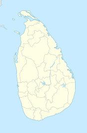
Sigiriya is located in Matale District]] in the Central Province of Sri Lanka.[5] It is within the cultural triangle, which includes five of the seven world heritage sites in Sri Lanka.[6]The Sigiriya rock is a hardened magma plug from an extinct and long-eroded volcano. It stands high above the surrounding plain, visible for miles in all directions. The rock rests on a steep mound that rises abruptly from the flat plain surrounding it. The rock itself rises 370 m (1,214 ft) above sea level and is sheer on all sides, in many places overhanging the base. It is elliptical in plan and has a flat top that slopes gradually along the long axis of the ellipse
History
In 477 CE, prince Kasyapa seized the throne from King Dhatusena, following a coup assisted by migara, the king’s nephew and army commander. Kasyapa, the king’s son by a non-royal consort, usurped the rightful heir, Moggallana, who fled to South India. Fearing an attack from Moggallana, Kasyapa moved the capital and his residence from the traditional capital of Anuradhapura to the more secure Sigiriya. During King Kasyapa’s reign (477 to 495), Sigiriya was developed into a complex city and fortress. Most of the elaborate constructions on the rock summit and around it, including defensive structures, palaces and gardens, date back to this period.kashyapa was defeated in 495 by Moggallana, who moved the capital again to Anuradhapura. Sigiriya was then turned back into a Buddhist monastery, which lasted until the thirteenth or fourteenth century. After this period, no records are found on Sigirya until the sixteenth and seventeenth centuries, when it was used as an outpost of the Kingdom of Kandy. When the kingdom ended, it was abandoned again.
The Mahavamsa, the ancient historical record of Sri Lanka, describes King Kasyapa as the son of King Dhatusena. Kasyapa murdered his father by walling him alive and then usurping the throne which rightfully belonged to his brother Mogallana, Dhatusena's son by the true queen. Mogallana fled to India to escape being assassinated by Kasyapa but vowed revenge. In India he raised an army with the intention of returning and retaking the throne of Sri Lanka which he considered was rightfully his. Knowing the inevitable return of Mogallana, Kasyapa is said to have built his palace on the summit of Sigiriya as a fortress and pleasure palace. Mogallana finally arrived and declared war. During the battle Kasyapa's armies abandoned him and he committed suicide by falling on his sword.
Chronicles and lore say that the battle-elephant on which Kasyapa was mounted changed course to take a strategic advantage, but the army misinterpreted the movement as the King having opted to retreat, prompting the army to abandon the king altogether. It is said that being too proud to be surrendered he took his dagger from the waist band, cut his throat, raised the dagger proudly, sheathed it and fell dead.[citation needed] Moggallana returned the capital to Anuradapura, converting Sigiriya into a monastery complex.
Alternative stories have the primary builder of Sigiriya as King Dhatusena, with Kasyapa finishing the work in honour of his father. Still other stories have Kasyapa as a playboy king, with Sigiriya a pleasure palace. Even Kasyapa's eventual fate is mutable. In some versions he is assassinated by poison administered by a concubine. In others he cuts his own throat when isolated in his final battle.[8] Still further interpretations have the site as the work of a Buddhist community, with no military function at all. This site may have been important in the competition between the Mahayana and Theravada Buddhist traditions in ancient Sri Lanka.
The earliest evidence of human habitation at Sigiriya was found from the Aligala rock shelter to the east of Sigiriya rock, indicating that the area was occupied nearly five thousand years ago during the mesolithic period.
Buddhist monastic settlements were established in the western and northern slopes of the boulder-strewn hills surrounding the Sigiriya rock, during the third century B.C. Several rock shelters or caves had been created during this period. These shelters were made under large boulders, with carved drip ledges around the cave mouths. Rock inscriptions are carved near the drip ledges on many of the shelters, recording the donation of the shelters to the Buddhist monastic order as residences. These have been made within the period between the third century B.C and the first century CE
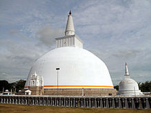
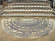
Anuradhapura
| Anuradhapura | |
|---|---|
| Kuttam Pokuna | |
| Coordinates: 8°21′N 80°23′E / 8.35°N 80.383°ECoordinates: 8°21′N 80°23′E / 8.35°N 80.383°E | |
| Country | |
| Province | North Central Province |
| Established | 4th century BC |
| Area | |
| - Total | 2,771.8 sq mi (7,179 km2) |
| - Land | 2,573 sq mi (6,664 km2) |
| - Water | 198.8 sq mi (515 km2) |
| Population (2001) | |
| - Total | 53,151 |
| - Density | 20.7/sq mi (8/km2) |
| Time zone | Sri Lanka Standard Time Zone (UTC+5:30) |
The city, now a UNESCO World Heritage Site, lies 205 km north of the current capital Colombo in Sri Lanka's North Central Province, on the banks of the historic Malvathu Oya.
From the 4th century BC, it was the capital of Sri Lanka until the beginning of the 11th century AD. During this period it remained one of the most stable and durable centers of political power and urban life in South Asia. The ancient city, considered sacred to the Buddhist world, is today surrounded by monasteries covering an area of over sixteen square miles (40 km²).
The city
- Protohistoric Iron Age
Further excavations in Anuradhapura have uncovered information about the existence of a protohistoric habitation of humans in the citadel. The protohistoric Iron Age which spans from 900 to 600 BC, marked the appearance of iron technology, pottery, the horse, domestic cattle and paddy cultivation. In the time period 700 to 600 BC the settlement in Anuradhapura had grown over an area of at least 50 ha. The city was strategically situated of major ports northwest and northeast, it was surrounded by irrigable and fertile land. The city was also buried deep in the jungle providing natural defence from invaders.
- Lower Early Historic period
Buddhism and Anuradhapura
With the introduction of Buddhism, the city gained more prominence and the great building era began. The Mahavamsa states that King Kutakannatissa built the first city wall to a height of seven cubits with a moat in front of the wall. This fortification was further enlarged by raising the wall a further 11 cubits to 18 cubits by King Vasabha. The king also added fortified gatehouses at the entrances of which the ruins can be seen to date. The Mahavamsa also states that soothsayers and architects were consulted in the construction.[edit] Great Building Era
[edit] The city grows
The city's popularity grew both as a ritual centre and as the administrative centre, a large population was attracted to the city for permanent settlement. Thus the living facilities were improved to accommodate the expanding population. King Vasabha constructed many ponds which were fed by a network of subterranean channels which were constructed to supply water to the city. Tissa and Abhayavapi tanks were built, the Nuwara weva was built and the Malwatu Oya was dammed to build the Nachchaduwa wewa which was 4408 acres (17.84 km²) in size.Parks were also provided in the city. The Ranmasu Uyana below the bund of Tissavapi or Tisa weva was one such, but it was strictly reserved for the members of the royal family. Health care and education were two other aspects to which the authorities paid attention. There were several hospitals in the city. In the fourth century King Upatissa II provided quarters and homes for the crippled and the blind. King Buddhadasa (337-365 AD), himself a physician of great repute, appointed a physician to be in charge of every ten villages. For the maintenance of these physicians, one tenth of the income from the fields was set apart. He also set up refuges for the sick in every village. Physicians were also appointed to look after the animals. Kassapa V (914-923 AD) founded a hospital close to the southern gate of Anuradhapura. General Sena in the tenth century is believed to have built a hospital close to the ceremonial street (Managala Veediya). The history of medical care began early, for in the fourth century BC King Pandukhabaya, in the course of sanitizing the town constructed a hospital. A large workforce was entrusted with the task of keeping the city clean.
Large lakes were also constructed by the city's rulers to irrigate paddy lands and also to supply water to the city. Nuwara wewa and Tissa wewa are among the best known lakes in the city.
Jaffna
| This article or section is in the middle of an expansion or major restructuring. You are welcome to assist in its construction by editing it as well. If this article has not been edited in several days, please remove this template. This article was last edited by Kanatonian (talk | contribs) 40 seconds ago. (Purge) |
For other uses, see Jaffna (dissambiguation).
| Jaffna யாழ்ப்பாணம் යාපනය | |
|---|---|
| — City — | |
| Coordinates: 9°40′0″N 80°0′0″E / 9.666667°N 80°E | |
| Country | Sri Lanka |
| Province | Northern |
| District | Jaffna |
| Government | |
| - Type | Municipal Council |
| - Mayor | Yogeswari Patkunarajah (Eelam People's Democratic Party) |
| Area | |
| - Total | 20.2 km2 (7.8 sq mi) |
| Population (2010) | |
| - Total | 84,416 |
| - Density | 4,179/km2 (10,823/sq mi) |
| Time zone | Sri Lanka Standard Time Zone (UTC+5:30) |
| Website | Jaffna city website |
Historically, Jaffna has been a contested city. It was made into a modern port town during the Portuguese occupation of the Jaffna peninsula in 1619. It changed hands to the Dutch colonials, who lost it to the British in 1796. After Sri Lanka gained independence 1948, the political relationship between the minority Sri Lankan Tamils and majority Sinhalese worsened and a civil war erupted in 1983. Jaffna was occupied by the rebel Liberation Tigers of Tamil Eelam (LTTE) in 1986 and from 1989 until 1995. Indian Peace Keeping Force (IPKF) briefly occupied the city in 1987. The Sri Lankan military gained full control in 1995.
Majority of the city’s population are Sri Lankan Tamils, although there was a significant number of Sri Lankan Moors, Indian Tamils and other ethnic groups present in the city prior to the civil war. Most Sri Lankan Tamils are Hindus followed by Christians, Muslims and as small Buddhist minority. The city is home to number educational institutions established during the colonial and post-colonial period. It has number of commercial institutions, minor industrial units, banks, hotels and others government institutions such as the Hospital. It is also home to the popular Jaffna library that was burnt down and rebuilt. The city is anchored by the Jaffna fort rebuilt during the Dutch colonial period.
History
Prior to the military capitulation to the Portuguese Empire in 1619, the capital of the native Jaffna Kingdom, also known as the Kingdom of the Aryacakravarti was Nallur. Nallur is partly within the city limits of Jaffna. It was known in royal inscriptions and chronicles as Cinkainakar and in other sources as Yalpaanam in Tamil and Yapaapatuna in Sinhalese.[1][edit] Colonial history
From 1590, Portuguese merchants and Catholic missionaries were active within the Jaffna kingdom. Impetus for a permanent fortified settlement happened only after 1619, when the expeditionary forces of the Portuguese Empire led by Phillippe de Oliveira captured the last native king Cankili II. Phillipe de Oliveira moved the center of political and military control from Nallur to Jaffnapatao (variously spelt as Jaffnapattan or Jaffnapattam), the Portuguese rendition of the native name for the former Royal capital.[2] Jaffnapatao was attacked number of times by a local rebel Migapulle Arachchi and his allied Thanjavur Nayakar expeditionary forces but the Portufuese defense of the city withstood the attacks.[3] Jaffnapatao was a small town. It had a fort, a harbor and Catholic chapels and other government buildings.[4] Portuguese merchants took over the lucrative trade of Elephants from the interior and monopolized the import of goods from Colombo and India thus disfranchising the local merchants.[3] Portuguese period was a time of population movement to the Vannimais in the south, religious change and as well as introduction of many European educational and health care methods to the city.[3]In 1658, Portuguese lost Jaffapatao to the Dutch East India Company (VOC) after a three month siege.[1] During the Dutch occupation, the city grew in population and size. Dutch were also tolerant towards native mercantile and religious activities. Most Hindu temples that were destroyed by the Portuguese were rebuilt. A community of mixed Eurasian Dutch Burghers formed and became part of the city during this period. The Dutch expanded rebuilt the fort considerably, built notable Presbyterian churches and other government buildings most which survived until the 1980s and were destroyed or damaged during the Civil war. During the Dutch period, Jaffna also became prominent as a trading town in locally grown agricultural products with the native merchants and farmers profiting as much as the VOC merchants. Great Britain took over Dutch possessions in Sri Lankan from 1796. Britain maintained many of the Dutch mercantile, tolerant religious and taxation policies. During the British colonial period, almost all the schools that eventually played role in the high literacy achievement of the Jaffna residents were built by missionaries belonging to American Ceylon Mission, Saivite reformer Arumuka Navalar and others. All the major roads and railway line connecting the city with Colombo, Kandy and the rest of the country were built. Under the British, Jaffna enjoyed a period of rapid growth and prosperity. The excess wealth of the citizens of the city was directed towards building civic projects like temples, schools, library and the museum.
[edit] Post-colonial history
After Sri Lanka became independent in 1948 from Britain, the relationship between majority Sinhalese and minority Tamils worsened. Residents of Jaffna city along with the rest of Tamil population of Sri Lanka were in the fore front of the political mobilization behind Tamil nationalist parties. After the Tamil conference incident in 1974, the then mayor of Jaffna Alfred Duraiappah was assassinated by the leader of rebel LTTE, Velupillai Prabhakaran in 1975. Following further deterioration of political discourse, the Jaffna library was burnt down in 1981 by Police and other miscreants. Failure of the political class to find an adequate compromise led to full scale civil war starting in 1983. Sri Lankan military and police were using the Dutch era fort as their encampment which was surrounded by various Tamil militants groups. Bombardment from air and land of the city led to damage to civic and civilian properties, death and injury to civilians and destruction the economic potential of the city. In 1986, the Sri Lankan military withdrew from the city and it came under the full control of the LTTE.In 1987, the Indian forces brought to Sri Lanka under the auspicious Indo- Sri Lankan peace accord led an operation to take the city from the rebels. It led to incidents like the Jaffna university hellidrop and Jaffna hospital massacre in which patients and medical workers were killed by the Indian Army. More than 200 civilians were also killed during attempt to take the city over by the IPKF. After the departure of the Indians, the city came under the control LTTE once more, but were ousted in 1995 after a 50 day siege. The economic embargo of the rebel controlled territories in general also had a negative impact in Jaffna including lack of power, critical medicines and food. During the period of LTTE occupation, all Muslim residents were expelled in 1990 and forced evacuated all residents in 1995. Since the end of civil war in 2009, refugees have begun to return and visible reconstruction has taken place. The Sri Lankan Tamil diaspora and business interests from Colombo has invested in commercial enterprises. Countries in Europe, US and India have shown an interest in investing in infrastructure projects and other economic activities.
[edit] Governance
The Jaffna Municipal Council governs the City of Jaffna. It was established under the Municipalities Ordinance Act of 1865. Although other cities such as Kandy, Galle and Colombo had elected municipal councils soon after the 1865 ordinance, Jaffna did not have an elected municipal council for many years. This reflected the desire of the British bureaucrats to govern the city directly rather than share power with a highly literate electorate.[5] The first elected mayor was Cathiravelu Ponnambalam.[6] Number of subsequent mayors were assassinated such as Alfred Duraiappah, Sarojini Yogeswaran and Pon Sivapalan. There were many years without elections since 1983.The post civil war elections were held in 2009 after a gap of 11 year. The municipal council consists of 29 members.[7] As the original municipal council building was destroyed during the civil war, a new building is to be constructed for the current municipal council in 2011.[8]
[edit] Geography and climate
The city is surrounded by Jaffna Lagoon to its west and south, Kokkuvil and Thirunelveli to the north, and Nallur to the east. Jaffna peninsula is made of limestone as it was submerged under sea during the Miocene period. The limestone is gray, yellow and white porous type. The entire land mass is flat and lies at sea level. Within one mile of the city center is the island of Mandativu which is connected by a causway. Palmyrah groves can be seen where land has not been used for construction. Other notable vegetation is a leafless shrub called talai (alae africana) and koddanai (oleander).Jaffna has the highest average temperature in Sri Lanka - 83° F (28° C). The temperature is highest in the months of April - May and August – September. The temperature is coolest in December – January. The annual rainfall is brought in by the North East monsoon and it varies from one place to the other and also from year to year. The average rainfall is 50 inches in the western part of Jaffna peninsula.
| Month | Jan | Feb | Mar | Apr | May | Jun | Jul | Aug | Sep | Oct | Nov | Dec | Year |
|---|---|---|---|---|---|---|---|---|---|---|---|---|---|
| Avg Temp °C (°F) | 25 (77) | 26 (78) | 27 (80) | 27 (80) | 27 (80) | 27 (80) | 26 (78) | 26 (78) | 26 (78) | 26 (78) | 26 (78) | 25 (77) | 26 (78) |
| Precipitation centimeters (inches) | 10.2 (4) | 8.6 (3.4) | 11.7 (4.6) | 24.1 (9.5) | 29.7 (11.7) | 20.6 (8.1) | 16.5 (6.5) | 15.5 (6.1) | 21.3 (8.4) | 34.0 (13.4) | 30.2 (11.9) | 17.8 (7) | 240.3 (94.6 |
Fox
"Vixen" redirects here. For other uses, see Vixen (disambiguation).
For other uses, see Fox (disambiguation).
| This article needs additional citations for verification. Please help improve this article by adding reliable references. Unsourced material may be challenged and removed. (May 2007) |
| Fox | |
|---|---|
 | |
| Red Fox (Vulpes vulpes) | |
| Scientific classification | |
| Kingdom: | Animalia |
| Phylum: | Chordata |
| Class: | Mammalia |
| Order: | Carnivora |
| Family: | Canidae |
| Tribe: | Vulpini |
| Genera | |
Members of about 37 species are referred to as foxes, of which only 12 species actually belong to the Vulpes genus of 'true foxes'. By far the most common and widespread species of fox is the red fox (Vulpes vulpes), although various species are found on almost every continent. The presence of fox-like carnivores all over the globe has led to their appearance in both popular culture and folklore in many cultures around the world (see also Foxes in culture). The gray fox is one of only two canine species known to climb trees; the other is the raccoon dog.
Etymology
The Modern English word "fox" is Old English, and comes from the Proto-Germanic word fukh – compare German Fuchs, Gothic fauho, Old Norse foa and Dutch vos. It corresponds to the Proto-Indo-European word puk- meaning "tail of it" (compare Sanskrit puccha, also "tail"). The bushy tail is also the source of the word for fox in Welsh: llwynog, from llwyn, "bush, grove".[1] Lithuanian: uodegis, from uodega, "tail", Portuguese: raposa, from rabo, "tail"[2] and Ojibwa: waagosh, from waa, which refers to the up and down "bounce" or flickering of an animal or its tail.[3] Male foxes are known as dogs or reynards, females as vixen, and young as kits, pups, or cubs.[4] A group of foxes is a "skulk", "troop" or "earth".General characteristics
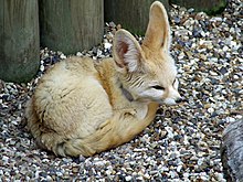
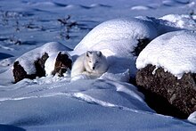
In the wild, foxes can live for up to 10 years, but most foxes only live for 2 to 3 years due to hunting, road accidents and diseases. Foxes are generally smaller than other members of the family Canidae such as wolves, jackals, and domestic dogs. Reynards (male foxes) weigh on average, 5.9 kilograms (13 lb) and vixens (female foxes) weigh less, at around 5.2 kilograms (11.5 lb). Fox-like features typically include a distinctive muzzle (a "fox face") and bushy tail. Other physical characteristics vary according to habitat. For example, the fennec fox (and other species of fox adapted to life in the desert, such as the kit fox) has large ears and short fur, whereas the Arctic fox has tiny ears and thick, insulating fur. Another example is the red fox which has a typical auburn pelt, the tail normally ending with white marking. Litter sizes can vary greatly according to species and environment - the Arctic Fox for example, has an average litter of four to five, with eleven as maximum.[5]
Unlike many canids, foxes are not usually pack animals. Typically, they live in small family groups, and are opportunistic feeders that hunt live prey (especially rodents). Using a pouncing technique practised from an early age, they are usually able to kill their prey quickly. Foxes also gather a wide variety of other foods ranging from grasshoppers to fruit and berries.
Foxes are normally extremely wary of humans and are not usually kept as indoor pets; however, the silver fox was successfully domesticated in Russia after a 45 year selective breeding program. This selective breeding also resulted in physical and behavioral traits appearing that are frequently seen in domestic cats, dogs, and other animals, such as pigmentation changes, floppy ears, and curly tails
Ox
This article is about cattle used for draft. For other uses of "ox" or "oxen", see Ox (disambiguation). For other uses of "bullock", see Bullock (disambiguation).
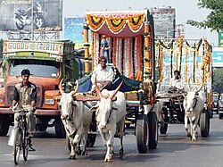
An ox (plural oxen), also known as a bullock in Australia, New Zealand and India, is a bovine trained as a draft animal. Oxen are commonly castrated adult male cattle (castration makes the animals more tractable), but cows (adult females) or bulls (intact males) may also be used in some areas.Oxen are used for plowing, for transport (pulling carts, hauling wagons and even riding), for threshing grain by trampling, and for powering machines that grind grain or supply irrigation among other purposes. Oxen may be also used to skid logs in forests, particularly in low-impact, select-cut logging.
Oxen are usually yoked in pairs. Light work such as carting household items on good roads might require just one pair, while for heavier work, further pairs would be added as necessary. A team used for a heavy load over difficult ground might exceed nine or ten pairs.
Contents[hide] |
[edit] Training
Working oxen are taught to respond to the signals of the teamster, bullocky or ox-driver. These signals are given by verbal command and body language, reinforced by a goad, whip or a long pole (which also serves as a measure of length: see rod). In pre-industrial times, most teamsters were known for their loud voices and forthright language.Verbal commands for draft animals vary widely throughout the world. In North America, the most common commands are:
- Get up: go
- Whoa: stop
- Back up: back up
- Gee: turn to the right
- Haw: turn to the left
A tradition in south eastern England was to use oxen (often Sussex cattle) as dual-purpose animals: for draft and beef. A plowing team of eight oxen normally consisted of four pairs aged a year apart. Every year, a pair of steers of about three years of age would be bought for each team and trained with the older animals. The pair would be kept for four years, then at about seven years old they would be sold to be fattened for beef – thus covering much of the cost of buying that year's new pair. Use of oxen for plowing survived in some areas of England (such as the South Downs) until the early twentieth century. Pairs of oxen were always hitched the same way round, and they were often given paired names (as in the well-known example of the names of Santa Claus's reindeer: Dasher and Dancer, Prancer and Vixen, Comet and Cupid, Donner and Blitzen). In southern England it was traditional to call the near-side (left) ox of a pair by a single-syllable name and the off-side (right) one by a longer name (for example: Lark and Linnet, Turk and Tiger).[1]
Ox trainers favor larger animals for their ability to do more work. Oxen are therefore usually of larger breeds, and are usually males because they are generally larger. Females can also be trained as oxen, but as well as being smaller, they are often more valued for producing calves and milk. Bulls are also used in many parts of the world, especially Asia and Africa.[2][3]
[edit] Uses and comparison to other draught animals
Oxen can pull heavier loads, and pull for a longer period of time than horses.[citation needed] On the other hand, they are also slower than horses, which has both advantages and disadvantages; their pulling style is steadier, but they cannot cover as much ground in a given period of time. For agricultural purposes, oxen were more suitable for heavy tasks such as breaking sod or ploughing in wet, heavy, or clayey, soil. When hauling freight, oxen could move very heavy loads in a slow and steady fashion. They are at a disadvantage compared to horses when it is necessary to pull a plow or load of freight relatively quickly.For millennia, oxen also could pull heavier loads due to the use of the yoke, which was designed to work best with the neck and shoulder anatomy of cattle. Until the invention of the horse collar, which allowed the horse to engage the pushing power of its hindquarters in moving a load, horses could not pull with their full strength because the yoke was incompatible with their anatomy.[citation needed]
Well-trained oxen in general are also considered less excitable than horses







No comments:
Post a Comment